The benefit of Web GIS is the fact that user are able to choose what and where to see from the given topics. Followings are some examples how to use the operatability to look for the point of interest.
1, Focus In!
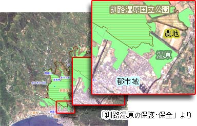
Focus into any area which seems interesting. ?Many of topics given have satelite map as naclground, so it is possible to compare such as the landuse from the data, and that from your visual sense.
The map above, for example, shows the map data of area of Kushiro wetland and Kushiro Wetland National Park on the sateluite map as background. By focusing into the south edge of thie GIS map, it is very clear to observed that the development for residencial and agricultural purposes reaches to such an edge of wetland area.
2. Change the Layer to be shown!
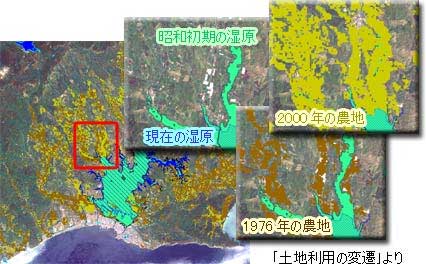
There are some topics to have data given along the time series. For such cases, try to change the layer to be shown.
This GIS map above, for example, have area of farmland of 1976 and 2000. It is clearly seen that the expansion of the farmland are so rapid from the comparison of those layer.
For each topics, there are some explanation what to be observed on the each of GIS map, but those are not the only fact we can learn from those maps. It is totally up to you to find what kind of information is on those maps, and that is the great possibility of Web GIS.